Share this Page on Facebook, Twitter or by Email:

Saturday, January 14, 2012

Subic Bay

Zambales, Luzon
Subic Bay Freeport Zone (SBF), which is known simply as Subic Bay, is the Philippines' first successful case of a military base converted through volunteerism into a tax- and duty-free zone similar to Hong Kong and Singapore, operated and managed by the Subic Bay Metropolitan Authority or SBMA. It covers the fenced area of the former U.S. Naval Base Subic Bay located in the southwest of Luzon Island in the Philippines and surrounded by the municipalities of Subic and Olongapo City in Zambales and Hermosa and Morong in Bataan, in concurrence of these municipalities' Sangguniang Bayan, pursuant to Section 12 of RA 7227. The harbor faces the Zambales Mountain Range to the west and the Subic Bay opening to the South China Sea. It is northwest of the Bataan Peninsula and southwest of Zambales Province.

SBF is 110 kilometers north of Manila. Manila Bay and the Bataan Peninsula separate SBF from Manila. The mountain ranges around the Subic Bay area and the deep natural harbor provide excellent and protected anchorage. In addition, these features make SBF naturally sheltered from typhoons as well as from the effects of an eruption of nearby Mt. Pinatubo.

Subic Bay Freeport is in Region III (or Central Luzon Region) of the Philippines. It is one of the points in the growth triangle (and an engine for economic development) in the region. SBF is a supplier of services and products for the Central Luzon Development Program, a regional growth area composed of the provinces of Bulacan, Nueva Ecija, Tarlac, Pampanga, Bataan, and Zambales.

Subic Bay is surrounded by the town of Subic and Olongapo City, both in the province of Zambales. Development of Olongapo City was largely tied to the presence of the United States Navy base at Subic Bay, once the largest U.S. military naval base in Asia. An arsenal and ship-repair facility was established at Subic Bay in 1885 by the then colonial power, Spain. Following the Spanish-American war, Subic Bay became a U.S. Navy and Marine base, and grew to be a major facility. Until 1991, it was the base of the United States 7th Fleet.

In early 1991, after the collapse of protracted negotiations, the Philippine Senate rejected terms for renewal of the lease of the base. The US Navy was already in the process of downsizing its Subic operations in June 1991, when Mount Pinatubo erupted. One of the largest volcanic eruptions in the last 100 years, it covered the Navy Base in volcanic ash and collapsed a significant number of structures. The last ship, USS Belleau Wood, left on November 24, 1992.

Surprisingly the departure of the Americans did not spell doom. Subic Bay was converted into a commercial zone largely through the efforts of some 8,000 residents of nearby Olongapo City, under the leadership of their mayor, Richard Gordon, who volunteered to protect and preserve 8 billion dollars worth of facilities and property from looting and destruction. Subic has since been transformed and became a model for bases conversion into commercial use after the Cold War with blue chip companies like Coastal Petroleum, and Fed Ex pumping in over $3 billion of investments creating 70,000 jobs in the free port's first four years. It was host to the 4th APEC Leaders' Summit on November 24, 1996 and . FedEx's Asia-Pacific hub, Asia-One, was also located in Subic Bay for almost ten years.
In addition to commercial use, Subic Bay is also a popular destination for weekend visitors from Metro Manila. Attractions include several beaches, an underwater aquarium, jungle survival tours, racing and duty-free shopping centers.

Subic Bay, the Philippines' first free port (see, Port of Subic), continues to be one of the country's major economic engines with more than 700 investment projects, including the 4th largest shipbuilding facility in the world (Hanjin Heavy Industries and Construction (HHIC)). Currently upgrading its port facilities through the Subic Bay Port Development Project and forging ties with the Clark Special Economic Zone in Angeles City, Pampanga to form the Subic-Clark Corridor via the 45-kilometer Subic-Clark-Tarlac Expressway, these once bastions of western military might are now being positioned to become the most competitive international service and logistics center in Southeast Asia.

As a destination, Subic Bay has maintained its allure that once charmed US servicemen and their families. Its community continues to preserve and protect the bay, its surrounding forests and its flora and fauna. Interesting sights to see are its resident eco-tourism theme parks, the Ocean Adventure, the country's only open-sea marine park, Zoobic Safari, and the Pamulaklakin Nature Park which is home to the indigenous Aetas who once trained the U.S. Navy jungle survival tactics.

Friday, January 13, 2012

San Juanico Bridge

Western Samar-Northern Leyte, Visayas


The San Juanico Bridge, part of the Pan-Philippine Highway, stretches from Samar to Leyte across the San Juanico Strait in the Philippines. Its longest length is a steel girder viaduct built on reinforced concrete piers, and its main span is of an arch-shaped truss design. With a total length of 2.16 kilometers (1.34 mi), it is the longest bridge in the Philippines spanning a body of seawater. It is considered one of the most beautifully designed bridges in Philippines. The bridge has 43 spans and medium size boats can pass beneath its large main arch the top of which rises 41 meters above the sea. Construction commenced in 1969 over San Juanico Strait from Cabalawan, Tacloban City to the municipality of Santa Rita, Samar, with completion in 1973.


The bridge was then named as Marcos Bridge after the era that was built upon. It was said to have been presented as a Gift and "Testimonial of Love" by the Philippine President Ferdinand Marcos to the first lady, Imelda, a native of Leyte.
The Candaba Viaduct of Pampanga which forms part of the North Luzon Expressway is longer, but being a land bridge crossing a few streams, ponds, and a swamp which usually fills in rainy weather, is less impressive.
Connecting Tacloban City on the Leyte side and Santa Rita town on the Samar side, it offers many picturesque views, especially of the San Juanico Strait with its thousand whirlpools as well as the islets of the province. It is approximately 10 minutes from downtown Tacloban City and is accessible by passenger jeepney, bus, motorcab or private vehicle.


Construction of the 21.9 million-dollar bridge was contracted to the Construction and Development Corporation of the Philippines (now the Philippine National Construction Corporation), which together with Japanese engineers conducted studies and designed the actual project.

Tuesday, January 10, 2012

Boracay

Aklan, Visayas


Boracay is an island of the Philippines located approximately 315 km (196 mi) south of Manila and 2 km off the northwest tip of Panay Island in the Western Visayas region of the Philippines. Boracay Island and its beaches have received awards numerous times. Boracay was awarded in the "Travelers' Choice 2011" by TripAdvisor as the second best beach (out of 25) in the world. Boracay made a debut appearance on the Top 10 Islands list in the Travel + Leisure travel magazine World's Best Awards 2011, ranking fourth.
The island comprises the barangays of Manoc-Manoc, Balabag, and Yapak (3 of the 17 barangays which make up the municipality of Malay), and is under the administrative control of the Philippine Tourism Authority in coordination with the Provincial Government of Aklan.
Boracay was originally home to the Ati tribe. Boracay is part of Aklan Province, which became an independent province on April 25, 1956.
In the late 1800s the island was "discovered" by Sofia Gonzales Tirol. She and her husband Lamberto Hontiveros Tirol, a town judge on nearby Panay island, took ownership of substantial properties and began to clear and develop the island.
Decades ago, Boracay Island was an almost possessively guarded secret so that only a few knew of its existence. Tourism only began to develop in the 1970s, after the movie 'Too Late the Hero' was filmed on locations in Boracay and Caticlan.
In the 1980s, the island became popular with backpackers. Since then, Boracay has gradually become a cosmopolitan tourism destination and, in the 21st century, has become one of the major tourist destinations in the Philippines.
Boracay Island is located off the northwest corner of Panay Island, and belongs to the Western Visayas island-group, or Region VI, of the Philippines. The island is approximately seven kilometers long, dog-bone shaped with the narrowest spot being less than one kilometer wide, and has a total land area of 10.32 square kilometers.
South-facing Cagban Beach is located across a small strait from the jetty port at Caticlan on Panay island, and the Cagban jetty port serves as Boracay's main entry and exit point during most of the year. When wind and sea conditions dictate, east-facing Tambisaan Beach serves as an alternative entry and exit point.
Boracay's two primary tourism beaches, White Beach and Bulabog Beach, are located on opposite sides of the island's narrow central area. White Beach faces westward and Bulabog Beach faces eastward. The island also has several other beaches.
White Beach is the main tourism beach. It is about four kilometers long and is lined with resorts, hotels, lodging houses, restaurants, and other tourism-related businesses. In the central portion, for about two kilometers, there is a footpath known as the Beachfront Path separating the beach itself from the establishments located along it. North and south of the Beachfront Path, beachfront establishments do literally front along the beach itself. Several roads and paths connect the Beachfront Path with Boracay's Main Road, a vehicular road which runs the length of the island. At the extreme northern end of White Beach, a footpath runs around the headland there and connects White Beach with Diniwid Beach.
Bulabog Beach, across the island from White Beach, is the second most popular tourism beach on the island and Boracay's main windsurfing and kiteboarding area.
Boracay is divided, for land use and conservation purposes, into 400 hectares of preserved forestland and 628.96 hectares of agricultural land.
Leisure activities available on or near Boracay include scuba diving, snorkeling, windsurfing, kiteboarding, cliff diving, and beach relaxation.
Boracay is the site of a 18-hole par 72 golf course designed by Graham Marsh. In addition, as of 2010, Boracay has in excess of 350 beach resorts offering more than 2,000 rooms ranging in quality from five-star to budget accommodation.

Brookes Point

Palawan, Luzon


Brookes Point is a 1st class municipality in the province of Palawan, Philippines.
Named after Sir James Brooke, the municipality has become famous for its promotion of ecotourism. It has also earned the distinction of being the original home of the biggest pearl in the world, known as the Pearl of Lao Tzu or the Pearl of Allah; found in its waters on May 7, 1934.
The name Brookes Point comes from an Englishman Sir James Brooke, first white Rajah of Sarawak and founder of the Brooke Dynasty. It is believed that during one of his voyages, he landed on the tip of an island with a long narrow stretch of land inhabited by native Palaweños and Muslims under the Sultanate of Sulu. Establishing trade and gaining the trust of the people, the name Brooke was so imprinted in the minds of the people that when American scouts came to the land almost a century later, they named it Brooke's Point.
Brookes Point is bounded in the North by the Municipality of Sofronio Española, in the South by the Municipality of Bataraza, in the West by the Municipality of Jose Rizal, and in the East by the Sulu Sea.
Barangay Oring-Oring, located some 7 kms from Poblacion proper is the birthplace of the World’s Biggest Pearl; known throughout the world as the Pearl of Allah or the Pearl of Lau-Tzu, this 14.1-pound porcelaneous pearl was found by a native Moslem in the seas of Oring-Oring. Valued in 1984 at USD $42 million, the ownership of this unique pearl is still in dispute. What is clear, however, is its origins: Oring-Oring, Brookes Point.The clam that gave birth to this pearl can still be found in the possession of the heirs of Panglima Pisi, the original owner of the pearl.


Also in Oring-Oring, another Natural Wonder can be found: the Ocean Spring. A few meters from the shore, submerged in the Sulu Sea are freshwater water springs with clean, fresh potable water.Today, the two identified springs are protected by a well, and is still used by the natives as a source of drinking water.
Mainit Falls and Hot Water Springs can be found 10 kilometers from the town proper, approximately 30 minutes by car. The Mainit Waterfalls not only serve to irrigate nearby fields but also serve as a source of drinking water to the residents living around its vicinity. Although Palawan stands outside the Ring of Fire, hot springs flow a few meters from the waterfall. Its sulfuric waters have been known to attract the Trogonoptera Trojana, a species of butterflies that is endemic to Palawan.


Bakbakan falls, a 64-meter waterfall can also be found in Barangay Mainit. Between Barangays Aribungos and Ipilan, Sabsaban Falls, also a frequently-visited site, acts as a natural boundary between the two towns.
Brookes Port, believed to have been constructed by Sir James Brooke himself, is a historical landmark in Brookes Point. Today, owing to erosion and the constant movement of the tides, only a few stones can still be seen in place.
Brookes Lighthouse is also believed to have been built by the Englishman. The remnants of the original lighthouse tower are still visible, although the area is now occupied by a new lighthouse.
Addison Peak, locally known as Mount Maruyog, with a height of 1,024 meters above sea level, is the highest point in Brookes Point and offers a panoramic view of the town and its surroundings.
At the edge of the town, sharing its boundaries with the Municipalities of Brookes Point, Bataraza, Sofronio Espanola, Quezon and Jose Rizal is Mount Mantalingahan with an elevation of 2,085 meters above sea level. Mount Mantalingahan is part of a series of mountain ranges that effectively divide the whole of Palawan into the East and West Coast.
Brookes Point has a modern sea port that may accommodate commercial passenger and cargo ships. from Manila, and Mindanao, as well as numerous fishing vessels.

Monday, January 9, 2012

Loboc River

Bohol, Visayas


The Loboc River is a river on Bohol Island, the Philippines. It is one of the major tourist destinations of Bohol, local and foreigners alike. The winding river plays host to cruises on board of small bancas or floating restaurants. Visitors are treated to a vista of lush tropical vegetation such as nipa palms, coconut trees, banana groves, and bushes.
The river plays a significant role in the history of Loboc before the Spaniards established the town in 1602. The early inhabitants made homes along the river.
It was in early 1980s that the idea to promote the Loboc River as a tourist destination started.
A cruise along the river starts either from the Loay Bridge (in Loay) or at the Poblacion of Loboc. The Loay Bridge is 20 kilometers (12 mi) from Tagbilaran City while the Poblacion is about 25 kilometers (16 mi) away. Small motorized bancas can be chartered for a minimal fee. For those who want to eat while cruising, floating restaurants are available offering Filipino cuisine buffet and local delicacies that costs P280 per head or more.
With the tourism fever, the floating restaurants were envisioned providing tourists with a first class dining experience on board floating restaurants. The floating vessels are made up of a covered platform on top of two large outrigger boats which are joined together. The boats can accommodate up to 50 people.
Most of the floating restaurants treat their guests with Boholano songs played by in-boat bands during the cruise. The trip winds up the river and ends at the Busay Falls which is only one and a half meter at most. Here, the guests are treated to rondalla music by a local rondalla group housed under a floating cottage.
Local folks usually take a dip in the waters and enjoy bathing under the falls. Guests who have brought with them extra clothes are welcome to swim and bathe and experience the heady feeling of a refreshing swim in the river’s unpolluted waters.


Going to and from the Busay Falls, visitors are treated to a spectacle of children diving from a large coconut tree that is leaning out towards the river. One will feel a bit tense seeing the children climbing up the tree and then plunging towards the deep waters. From the looks of it, the part of the tree where the children usually dive from is more than 10 feet (3.0 m) from the river.
Along the way, one can see children swimming and people passing by in small bancas or canoes. Upstream, and located on the eastern bank of the river, the Nuts Huts Resort is seen. This resort is a favorite hang-out for bikers and hikers who prefer the peaceful and scenic surroundings of the river bank rather than the majestic allure of the sea.

Another area worth visiting is where wild chickens, turtles, and pythons are kept in captivity. On this trips, visitors are given the time to marvel at the surrounding landscape. After a while, the return trip starts. Since the trip is going downstream, it takes a shorter time for the boats to arrive at the starting point.

Puerto Galera

Oriental Mindoro, Luzon


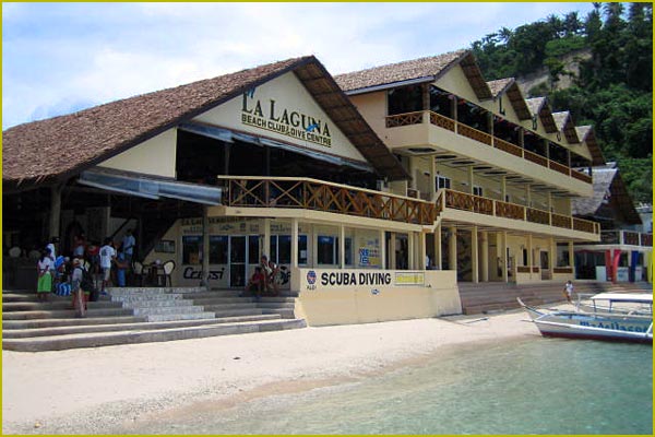
Puerto Galera is the northwesternmost municipality in the province of Oriental Mindoro, Philippines. This coastal town is well known among tourists for its numerous pocket beaches and many snorkeling and Scuba diving spots. The area was designated a Man and Biosphere Reserve of UNESCO in 1973 and has some of the most diverse coral reef diving in Asia. The marine environment has benefited in recent years from the influx of tourist dollars. This has seen a huge reduction in the number of fishermen in the area, as they gain higher revenue from tourists.
Puerto Galera is listed by the Club of the Most Beautiful Bays of the World, and is the only bay in the Philippines to be listed there. Among the famous beaches in Puerto Galera are Sabang Beach and White Beach, which have an active nightlife with numerous bars and restaurants. Both beaches also have an array of first-class and economy-class accommodations.


Sabang beach is the main destination for foreign tourists, while White Beach remains popular with local travelers.Big La Laguna Beach and Small La Laguna Beach are considered part of Sabang with resorts lining the beaches. Big La Laguna Beach is popular for local swimmers and snorkelers. Since 2001 White beach has seen uncontrolled development. New restaurants and places to stay are rapidly encroaching on the beach itself and little remains of the once charming beach. Puerto Galera town is a pleasant but sleepy Philippine town with few attractions. It has a large central catholic church and a Pier area, with a selection of bistros and cafes.


Behind the beaches are the huge and generally unexplored mountain ranges of central Mindoro. A particular local attraction is the nine hole golf course perched on the hillside above White Beach which commands spectacular views over Puerto Galera's natural harbor and the Verde Island Passage. Mangyan tribes are scattered over the mountain sides - some of the more remote tribes have virtually no contact with the outside world. Of the eight tribes on Mindoro, the Iraya are the largest. They are based in the Puerto Galera area.


Puerto Galera is among the top diving destination in the Philippines. Excellent diving is found less than 5 minutes from Sabang Beach. The diving generally focuses around the areas either side of Escarceo Point, which is famous for its current rips. Strong currents are a feature of the diving in Puerto Galera and it is good advice to employ the services of an experienced local guide or dive centre. There are more than thirty dive sites all within a 5-10 minute banca ride from Sabang Beach. Marine life is highly diverse. 180+ species of nudibranchs are found in the area and many species of fish can be seen. A variety of wrecks have been sunk over the years in addition to the one wreck of an engine of a WWII Japanese patrol boat.
Puerto Galera is also one of the main technical diving destinations in Asia. Technical Diving International - [TDI] has many dive centers in the area, offering the full range of TDI courses from Basic nitrox to advanced trimix.

Sunday, January 8, 2012

Guimaras

Panay, Visayas


Guimaras is an island province of the Philippines located in the Western Visayas region. The Guimaras Island is famous for producing the sweetest mangoes in the world. Among the smallest provinces, its capital is Jordan. The island is located in the Panay Gulf, between the islands of Panay and Negros. To the northwest is the province of Iloilo and to the southeast is Negros Occidental.
The province includes the islands of Guimaras and Inampulugan and many smaller islands.
Guimaras was a sub-province of Iloilo until it was made an independent province on May 22, 1992.

The people of Guimaras are considered as Guimarasnon and their languages are Hiligaynon and Kinaray-a as it was once a sub-province of Iloilo. Hiligaynon is the major language spoken, although the people can understand and speak Tagalog and English.

Located southwest of Panay, Guimaras is separated from Iloilo by the Iloilo Strait, a narrow channel which takes about fifteen minutes to cross by pumpboat from the Ortiz landing in Iloilo to Jordan, Guimaras. Other ferries leave from the Parola wharf in Iloilo to the municipality of Buenavista, Guimaras. The Parola wharf is used exclusively whenever the water is rough. There also is a roll on/roll off (RORO) ferry that travels around five times a day.


Geologists have concluded that the island formed one landmass with Panay. Guimaras was formerly known as Himal-us.
The province is basically agricultural with palay, coconut, mango, vegetables, livestock, poultry and fishing as major products. Its major industries are tourism, fruit processing, coconut processing, fish farming, handicrafts making, mining, quarrying and lime production.


Guimaras is well-known for its agricultural crops, particularly mangoes, where some 50,000 of these trees are planted. Guimaras mangos are reportedly served at the White House and Buckingham Palace. Guimaras' largest event of the year is The Manggahan Festival (the Mango Festival). The variety of mangoes produced are also best for making dried mangoes, jam and other delicacies.

Camiguin

Bohol, Mindanao


Camiguin is an island province of the Philippines located in the Bohol Sea, about 10 km (6.2 mi) off the northern coast of Misamis Oriental in Mindanao. It is the second-smallest province both in population and land area after Batanes. The capital of the province is Mambajao, and it is a part of the Northern Mindanao Region of the Philippines.
The name Camiguin is derived from the native word “Kamagong”, a species of the ebony tree that thrives near Lake Mainit in the Province of Surigao del Norte. Earlier inhabitants of the islands are Manobos from the Surigao region. An earlier Spanish geography book writes the island as "Camiguing". There is reason to suppose the Spaniards dropped the final g.
Lanzones Festival
Each year in October, a festival is held celebrating the Lanzones, a small grape-sized tropical fruit grown all over the island. The week-long Lanzones Festival is one of the more colorful events in the Philippines.
Churches
Several centuries-old Spanish Colonial and 20th century churches are found in various parts of the island.
Camiguin is of volcanic origin and composed of four young stratovolcanoes overlying older volcanic structures. The last eruption was from Hibok-Hibok in 1953, and it is still considered as active. The other major volcanic edifices are Mt. Vulcan 671 meters (2,201 ft), northwest of Hibok-Hibok; Mt. Mambajao 1,552 meters (5,092 ft) in central Camiguin; Mt. Guinsiliban 581 meters (1,906 ft), southernmost Camiguin; and Mt. Butay north of Mount Guinsiliban. The other domes and cones are Campana Hill, Minokol Hill, Tres Marias Hill, Mt. Carling, Mt. Tibane, and Piyakong Hill.
Santo Rosario Church
The famed Santo Rosario Church in the municipality of Sagay was built in 1882.
Old Catarman Church Ruins
The church of the Old Catarman town was destroyed and partly submerged by volcanic debris during the eruption and formation of Mt. Vulcan from 1871 to 1875. Also known as Gui-ob Church, only the ruins of the church and bell tower remains of the old town. An unsightly modern white lighthouse was recently erected close to the bell tower.
Baylao Church
The Church located in Baylao is claimed to be miraculous attributed to saving many lives during the last volcanic eruption of Hibok-hibok.
Old Ancestral Homes
Beautiful and ornate ancestral homes that date back to the Spanish Colonial Period and American Colonial Period, are still abundant and can be found on the streets of Camiguin.
White Island off the northern coast of Camiguin
Beautiful and ornate ancestral homes that date back to the Spanish Colonial Period and American Colonial Period, are still abundant and can be found on the streets of Camiguin.
Located just a few kilometers off the coast are the two beautiful islands of Camiguin.
White Island is accessed from Agoho which is about 5 km west of the town of Mambajao.
Mantigue Island can be reached from Mahinog about 14 km south of Mambajao.
Sunken Cemetery 
During the volcanic birth of the Mt. Vulcan that lasted from 1871 to about 1875, some areas in the town of Bonbon subsided, sinking the cemetery of the town to below sea level. The place is commemorated by a huge cross erected in 1982.
Waterfalls
Katibawasan Falls. Located 5 km. (3.1 mi) southeast of Mambajao, the beautiful Katibawasan Falls cascades 250-foot (76 m.) down to a pool surrounded by orchids and ferns. An invigorating dip on the pool is popular especially on warmer days and several hiking trails are within the park. This is also the favorite jump-off point for trekkers and mountaineers in search of adventure on the slopes of Mt. Hibok-Hibok.
Tuasan Falls is located 6 km. (3.7 mi) northeast of Catarman. Getting to the falls entails a very scenic hike passing through the quaint Barrio of Mainit, Catarman and along the rocky river bed. The pool below the waterfalls is deep and clear. The surrounding scenery is unspoiled and perfect for a peaceful picnic, the only sounds around you is that of the tumbling falls and running water.

Springs
Ardent Hot Spring. Located at the foot of Hibok-Hibok Volcano bubbles the mineral pools of Ardent Hot Springs. Wisps of steam can be seen rising from the running waters heated up by the cauldron of the mountain, the most recently active of the seven volcanoes on the island.
Sto. Niño Cold Springs and Bura Natural Soda Water Swimming Pool in Catarman are other popular places to get a relaxing dip on the island.
Ferry to Camiguin with Mount Guinsiliban in the background
Tangub Hot Spring is an interesting hot spring located on the shore close to the Sunken Cemetery. Most of the spring is submerged and can be partly seen during low tide. The spring can also be examined by scuba diving or snorkeling, as visibility is excellent and it is also a recommended spot for observing underwater life.

Thursday, January 5, 2012

Siargao

Surigao del Norte, Mindanao


Siargao is a tear-drop shaped island in the Philippine Sea situated 800 kilometers southeast of Manila in the province of Surigao del Norte. It has a land area of approximately 437 square kilometers. The east coast is relatively straight with one deep inlet, Port Pilar. The coastline is marked by a succession of reefs, small points and white, sandy beaches. The neighboring islands and islets have similar landforms.
Siargao Island contains the largest mangrove forest reserves in Mindanao, at Del Carmen. Long stretches of wetlands indicate a potential for commercial seaweed propagation. Siargao Island is greatly influenced by the winds and currents coming uninterrupted from the Pacific Ocean, intensified by the Mindanao current running westward through the Siargao Strait.
Siargao Island is situated at a coordinate of 9°52'N 126°03'E. It is composed of municipalities of Burgos, Dapa, Del Carmen, General Luna, San Benito, Pilar, San Isidro, Santa Monica and Socorro.
Offshore, a classic tropical island lies protected within its surrounding coral reef with dozens of coconut palms dressed in the center circle of the island. Off to the right, well within the massive coastal reef, lies a shining white sand bar, (Pansukian, or Naked island) some 200 meters long. The tide of Siargao is diurnal with tidal curves typically present, especially on the east coast of the island.
The Island's Pacific-facing reefs are situated on the edge of the Philippine Trench, and the extremely deep offshore waters assure the ocean swells have undiluted power when they encounter the many coral and rock reefs. Siargao has excellent surfing conditions, particularly during the southwest "habagat" monsoon from August to November, when the prevailing wind is offshore.
In the past, going to Siargao is by domestic flights from Manila to Surigao, and then by boat to Siargao Island. Beginning March 4, 2011 however, the easiest, fastest, most convenient way to the island is now by flying Cebu Pacific direct to Siargao Island via Cebu.
One of the best known surfing waves on Siargao and the Philippines, with a worldwide reputation for thick, hollow tubes is "Cloud 9". This right-breaking reef wave is the site of the annual Siargao Cup, a domestic and international surfing competition sponsored by the provincial government of Surigao del Norte.
The wave was discovered by travelling surfers in the late 1980s. It was named and made famous by American photographer John S. Callahan, who published the first major feature on Siargao Island in the United States- based Surfer magazine in March 1993, and hundreds of his photos in many other books and magazines since his first visit in 1992. Callahan has put the island on the international map and has drawn thousands of surfers and tourists to Siargao. Cloud 9 also has a reputation for being a relatively cheap destination for surfers with many cheap accommodations and restaurants and bars to choose from.
There are several other quality waves on Siargao and nearby islands, but Cloud 9 has received more publicity than any other, indeed in the Philippines as a whole. It is the only wave easily accessible without a boat, leading to overcrowding and the nickname of "Crowd 9" among surfers. Eager foreign and locally owned accommodation and tourist facilities have profited from the magazine publicity and the influx of visitors drawn by the annual Siargao Cup competition in September.
Siargao is well known as "The Surfing Capital of the Philippines" with a reputation among surfers within the Philippines and the International scene. Eddie Florano has also written a song called "Surfin' in Siargao" from the 2006 Ukulele World: Acoustic & Power Ukulele compilation album.

Wednesday, January 4, 2012

Vigan

Ilocos Sur, Luzon


The City of Vigan is a World Heritage Site in that it is one of the few Hispanic towns left in the Philippines, and is well-known for its cobblestone streets, and a unique architecture that fuses Philippine and Oriental building designs and construction, with colonial European architecture.
The area of Vigan was originally a settlement of traders coming from the Fujian Province, China. At the time of Spanish colonisation, the Chinese settlers, whose language was Southern Fujianese (Min Nan, often referred to as "Hokkien" by most Filipinos), referred to the area as "Bee Gan", which means "Beautiful Shore." Since the Castillian and Basque Spanish conquistadors interchanged V and the B to refer to the B sound, they spelled the Hokkien Chinese name "Bee Gan" as "Vigan", which is the name used to this day.
Vigan's Chinese heritage is still evident from the numerous elite Chinese creole families who come from the area, many of whom adopted Hispanic family names. Others, such as the Sy-Quia family, have retained Chinese-derived surnames, though most, if not all, of the Christian Chinese creole families fully Hispanicised themselves culturally.
The most commonly known source of the city's name is from the Biga'a plant, which once grew abundantly along the banks of the Meztiso River, from which captain Juan de Salcedo derived the city's name (after a misunderstanding with the locals, thinking he was asking the name of the plants).
Vigan is an island which is separated from the mainland by three bodies of water:[citation needed] the Abra River, the Mestizo River, and the Govantes River. The city is unique in the Philippines because it is one of many extensive surviving Philippine historic cities, dating back to the 16th century.
Vigan was a coastal trading post long before the Spaniards arrived; Chinese traders sailing from the South China Sea came to Isla de Vigan (Island of Vigan) via the Mestizo River that surrounded the island. On board their ships were sea-faring merchants that came to trade goods from other Asian kingdoms in exchange for gold, beeswax, and other mountain products brought by the indigenous peoples from the Cordilleras region.
Thus, after the successful expedition and the exploration of the North, Juan de Salcedo founded "Villa Fernandina de Vigan" in honor of King Philip II’s son, Prince Ferdinand, who died at the age of four. From Vigan, Salcedo rounded the tip of Luzon and proceeded to pacify Camarines, Albay, and Catanduanes.
As a reward for his services to the King of Spain, Salcedo was awarded the old province of Ilocos which consisted of the modern provinces of Ilocos Norte, Ilocos Sur, Abra, La Union and part of Mountain Province as his hacienda (estate), and was accorded the title of "Justicia Mayor de esta Provincia de Ylocos" (Province Mayor of Ilocos).
In 1576, Salcedo returned to the capital of his encomienda (trusteeship), Vigan, bringing with him his soldiers, and some Augustinian missionaries to pioneer the evangelization of the Ilocos region. He established a Spanish city for the purpose of controlling the neighboring country.
Governor General Gómez Pérez Dasmariñas, in his Account of encomienda dated in Manila on May 31, 1591 states: "The town of Vigan called Villa Fernandina consisted of Spanish settlers; a priest; a Justice Alcalde Mayor (Governor); and a Deputy. The King collects 800 tributes (equivalent to 3,200 subjects)." During this period, Vigan was composed of 19 barrios (districts).
Between 1645 to 1660, Vigan was divided into 21 Cavezas de Barrios (Town Mayors) as mentioned in the Libro de Casamiento (Book of Marriage); from the records of the parish house of Vigan found in its Archives. Separated from the indigenous population; the Chinese migrants were residents in a neighbourhood called pariancillo, Los Sangleyes del parian (The Sangleyes of Parian); and the Spanish settlers were residents in a town called Los Españoles de la Villa (The Town of the Spaniards).
During the Philippine Revolution of 1896 to 1898, Philippine Revolutionary forces, supported by the Ilocano rebels, attacked and defeated the Spanish Colonial forces and captured the city in the Siege of Vigan. Starting from the Philippine-American War from 1899 to 1901, American Colonial troops occupied the city. Forces led by Col. James Parker occupied the Cathedral.
During World War II, Japanese Imperial Army planes bombed Vigan on December 1941 and Japanese troops occupied the town in 1942. In 1945, combined U.S. and Philippine Commonwealth ground troops, aided by Ilocano resistance fighters, defeated the Japanese Imperial forces and liberated Vigan.

Baguio

Benguet, Luzon


Baguio is nicknamed as the "Summer Capital of the Philippines". Owing to its high elevation, the temperature in the city is 8 degrees Celsius lower compared to the average temperature of the rest of the country.The City of Baguio is a highly urbanized city located in northern Luzon island in the Philippines. The city has become the center of business and commerce as well as the center of education in the entire Northern Luzon thereby becoming the seat of government of the Cordillera Administrative Region. According to the 2007 census, Baguio City has a population of 301,926.
Baguio City was established by Americans in 1900 at the site of an Ibaloi village known as Kafagway. The name of the city is derived from the word bagiw in Ibaloi, the indigenous language of the Benguet Region, meaning 'moss'. The city is at an altitude of approximately 1,500 metres (4,900 ft) in the Luzon tropical pine forests ecoregion conducive to the growth of mossy plants and orchids.
Because of its altitude, Baguio City was designated by the Philippine Commission as the Summer Capital of the Philippines on June 1, 1903. It was incorporated as a chartered city by the Philippine Assembly on September 1, 1909, as authored by former Philippines Supreme Court Justice George A. Malcolm. The City of Baguio celebrated its Centennial last September 1, 2009.
The region around Baguio was first settled primarily by the Ibalois and the Kankanaeys. In the nearby town of La Trinidad, Benguet, Spaniards established a commandante or military garrison, but Kafagway, as Baguio was once known, was barely touched.
Baguio City is located some 1,500 meters above sea level, nestled within the Cordillera Central mountain range in northern Luzon. The city is enclosed by the province of Benguet. It covers a small area of 57.5 square kilometers. Most of the developed part of the city is built on uneven, hilly terrain of the northern section. When Daniel Burnham plotted the plans for the city, he made the City Hall as a reference point where the city limits extend 8.2 kilometres (5.1 mi) from east to west and 7.2 kilometres (4.5 mi) from north to south. It is the highest major Philippine city in terms of elevation.
Baguio City features a subtropical highland climate under the Koppen climate classification. The city is known for its mild climate. Average temperature ranges from 15 to 23 degrees Celsius. It is usually lower during the late and early months of the year. The lowest recorded temperature was 6.3 degrees Celsius on January 18, 1961. This is in contrast to the all-time high of 30.4 degrees Celsius recorded on March 15, 1988 during the 1988 El Niño season. Baguio seldom exceeds 26 degrees Celsius even during the warmest part of the year.
Like many other cities with a subtropical highland climate, Baguio sees noticeably less precipitation during its dry season. However, the city has an extraordinary amount of precipitation during the rainy season, with the months of July and August having on average more than 1,000 mm of rain. Baguio averages over 4500 mm of precipitation annually.
Tourism is one of Baguio's main industries due to its weather and history. During the year end holidays some people from the lowlands prefer spending their vacation in Baguio, to experience cold temperatures they rarely have in their home provinces. Also, during summer, especially during Holy Week, tourists from all over the country flock to the city. During this time, the total number of people in the city doubles. To accommodate all these people there are more than 80 hotels and inns available. Local festivities such as the Panagbenga Festival also attract both local and foreign tourists. Baguio is the lone Philippine destination in the 2011 TripAdvisor Traveler's Choice Destinations Awards, Asia category, with the city being among the top 25 destinations in Asia.

Tuesday, January 3, 2012

Rizal Monument

Manila, Luzon


Rizal Monument, also known as Luneta Park or colloquially Luneta, is a historical urban park located in the heart of the city of Manila, Philippines, adjacent to the old walled city of Manila, now Intramuros. Since the Spanish Colonial Era, the park has been a favorite spot for unwinding, socializing, an urban oasis for family picnics on Sundays and holidays. It is one of the major tourist attractions of Manila.
Located along Manila Bay, Luneta has been the site of some of the most significant moments in Philippine history. The execution of pacifist Dr. José Rizal on December 30, 1896, sparked the fire of the Philippine Revolution against the Spanish colonizers, elevating the martyr as the national hero of the country. The park was officially renamed Rizal Park in his honor and his monument serves as the symbolic focal point of the park. The Declaration of Philippine Independence from American rule was held here on July 4, 1946 as well as the political rallies of Ferdinand Marcos and Corazon Aquino in 1986 that led to the EDSA Revolution deposing the dictator.

Luneta is situated at the northern terminus of Roxas Boulevard. To the east of the boulevard, the park is bounded by Taft Avenue, Padre Burgos Drive and T.M. Kalaw Avenue. To the west is the reclaimed area of the park bounded by Katigbak Dr., South Dr., and the shore of Manila Bay.

Rizal Park's history began in 1820 when the Paseo de Luneta was completed just south of the walls of Manila on a marshy patch of land next to the beach during the Spanish rule. Prior to the park, the marshy land was the location of a small town called Nuevo Barrio (New Town or Bagumbayan in Tagalog language) that dates back to 1601; it was cleared during the short British rule in 1762 to prevent sneak attacks from the patriotic natives. The area later became known as Bagumbayan Field where the Cuartel la Luneta (Luneta Barracks), a Spanish Military Hospital (which was destroyed by one of the earthquakes of Manila), and a moat-surrounded outwork of the walled city of Manila, known as the Luneta (lunette) because of its crescent shape.
West of Bagumbayan Field is the Paseo de la Luneta (Plaza of the Lunette) named after the fortification, not because of the shape of the plaza which is a long 100-by-300-metre (330 × 980 ft) rectangle ended by two semicircles. It was also named Paseo de Alfonso XII (Plaza of Alfonso XII), after Alfonso XII, King of Spain during his reign from 1874 to 1885. Paseo de la Luneta was the center of social activity for the people of Manila in the early evening hours. This plaza is arranged with paths and lawns and surrounded by a wide driveway called "La Calzada" (The Road) where carriages circulate.

During the Spanish period, most especially in the latter part of the 19th century, the place became notorious for public executions of criminals and political enemies of Spain. On February 17, 1872, three Filipino priests, Mariano Gómez, José Burgos, and Jacinto Zamora, collectively known as Gomburza, were executed by garrote, accused of subversion arising from the 1872 Cavite mutiny.

The bronze-and-granite Rizal monument is among the most famous sculptural landmarks in the country. It is almost protocol for visiting dignitaries to lay a wreath at the monument. Located on the monument is not merely the statue of the national hero, but also his remains.
On September 28, 1901, the United States Philippine Commission approved Act No. 243, which would erect a monument in Luneta to commemorate the memory of José Rizal, Philippine patriot, writer and poet. The committee formed by the act held an international design competition between 1905–1907 and invited sculptors from Europe and the United States to submit entries with an estimated cost of ?100,000 using local materials.
The first-prize winner was Carlos Nicoli of Carrara, Italy for his scaled plaster model titled “Al Martir de Bagumbayan” (To the Martyr of Bagumbayan) besting 40 other accepted entries. The contract though, was awarded to second-placer Swiss sculptor named Richard Kissling for his “Motto Stella” (Guiding Star).
After more than twelve years of its approval, the shrine was finally unveiled on December 30, 1913 during Rizal’s 17th death anniversary. His poem "Mi Ultimo Adios" ("My Last Farewell") is inscribed on the memorial plaque. The site is continuously guarded by ceremonial soldiers, known as Kabalyeros de Rizal (Knights of Rizal).

The Independence Flagpole, standing at 107 metres (351 ft), is the highest flagpole in the Philippines. On this spot in front of Rizal Monument, at 9:15am July 4, 1946, the full independence of the Republic of the Philippines was proclaimed as authorized by the United States President Harry S. Truman. Next to the flagpole, a grand Independence Grandstand, designed by architect Juan Arellano, was built just for the occasion.

Quirino Grandstand. In 1949, a permanent grandstand, a replica of the Independence Grandstand was completed along Manila Bay where President Elpidio Quirino was sworn in after winning the presidential election. Since then, newly-elected Presidents of the Philippines traditionally take their oath of office and deliver their inaugural address to the nation in the grandstand, which was later renamed after President Quirino. Many important political, cultural and religious events in the post war era have been held here.

On June 12, 1998, mammoth festivities capped the 1998 Philippine Centennial Celebrations, marking a hundred years of the Philippine Declaration of Independence from Spain, culminating to the establishment of the First Philippine Republic. Celebrations were led by then president of the country Fidel V. Ramos.

Tubbataha Reef

Palawan, Luzon


Tubbataha Reef is an atoll coral reef located in the Sulu Sea of the Philippines. It is a marine sanctuary protected as Tubbataha Reef National Marine Park. It is nominated at the New 7 Wonders of Nature.

The word tubbataha is a combination of two Samal words: tubba and taha, which together means "a long reef exposed at low tide".

Tubbataha is located in the Sulu Sea, 98 nautical miles (181 km) southeast of Puerto Princesa City in the Palawan Province. The reef is made up of two coral atolls divided by an eight-kilometer (5 miles) wide channel. The South Atoll, the smaller of the two is five kilometers in length and three kilometers in width; while the North Atoll, the larger of the two is 16 kilometers (9.9 mi) long and five kilometers (3 miles) wide.(Knipp 22) Each reef has a single small islet that protrudes from the water. The atolls are separated by a deep channel 8 km (5.0 mi) wide.
There are no permanent inhabitants of the islets or reefs. Fishermen visit the area seasonally, establishing shelters on the islets. The park is visited by tourists, particularly divers. Trips to Tubbattaha from mid-March to mid-June are all vessel-based; the park is about twelve hours by boat from Puerto Princesa City. Tubbataha is considered as the best dive site in the Philippines and the diving dedicated ships that operate during the "Tubbataha Season" are usually booked years in advance especially during the Asian holidays of Easter and "Golden Week".

Tubbataha has become a popular site for seasoned sports divers because of its coral "walls" where the shallow coral reef abruptly ends giving way to great depths. These "walls" are not only wonderful diving spots but they are also wonderful habitats for many colonies of fish. There are giant trevally (jacks), hammerhead sharks, barracudas, manta rays, palm-sized Moorish idols, napoleon wrasse, parrotfish, and moray eels living in the sanctuary. There also have been reported sightings of whale sharks and tiger sharks. Tubbataha is even home to the hawksbill sea turtles (Eretmochelys imbricata) which are endangered species.

Over 1000 species inhabit in the reef; many are already considered as endangered. Animal species found include manta rays, lionfish, sea turtles, clownfish, and sharks.
Vivid corals cover more than two-thirds of the area and the waters around the reef are places of refuge for numerous marine lives. The seemingly diverse ecosystem of this sanctuary rivals the Great Barrier Reef – having 350 coral species and 500 fish species. In June 2009 an outbreak of the crown-of-thorns starfish was observed, possibly affecting the ecological functioning of this relatively pristine coral reef.
Aside from being a marine sanctuary, Tubbataha is also renowned for being a bird sanctuary. A lighthouse islet, at the southern tip of the South Atoll, supports a large number of seabirds which nest there. Around the Tubbataha, there are tens of thousands of masked red-foot boobies, terns, and frigate birds resting during their annual migrations. To minimize any external intrusions, the Philippine Coast Guard maintains a small monitoring station on one of the many permanent sand bars.

The Tubbataha National Marine Park is open to live-aboard diving excursions between the months of April to June. It is in this period where the waves are most calm. As of March 2011, the park entrance fee is pegged at USD $75.00 or PHP 3,000.00. Due to global warming, it is advised that divers book their trips towards the middle or end of April as the waves are still strong and may cause problems for dive excursions and underwater visibility.
Although the sand bars around Tubbataha are considered off limits to human beings, tourists are allowed to set foot at the Ranger Station where they can purchase souvenirs and tour the facility.

Laguna de Bay

Laguna, Luzon


Laguna de Bay (Filipino: Lawa ng Bay; English: Lake of Bay) is the largest lake in the Philippines and the third largest freshwater lake in Southeast Asia (in terms of surface area) after Tonle Sap in Cambodia and Lake Toba in Sumatra, Indonesia. It is on the island of Luzon between the provinces of Laguna to the south and Rizal to the north. Metro Manila lies on its western shore. Its surface area is about 911 square kilometres (352 sq mi) with an average depth of only about 2.8 metres (9 ft 2 in) and elevation of about 1 metre (3 ft 3 in) above sea level. The lake is shaped like a stylized 'W', with two peninsulas jutting out from the northern shore. Between these peninsulas, the middle lobe fills the large volcanic Laguna Caldera. Laguna de Bay drains to Manila Bay via the Pasig River. The lake is one of the primary sources of freshwater fish in the country.
There is a large island in the lake, Talim Island, which is under the jurisdiction of the towns of Binangonan and Cardona in Rizal province.

"Laguna de Bay" is the Old Spanish term for "Lake of Bay". "Laguna" is the Spanish word for "Lake", and Bay (pronounced as bä'ï) is a town in Laguna province, along the south shore of the lake.
In the pre-Hispanic era, the lake was known as "Puliran Kasumuran" (Laguna Copperplate Inscription. 900 AD), and later by "Pulilan" (Vocabulario de Lengua Tagala.1613. Pila, Laguna).

The middle part of Laguna de Bay between Mt. Sembrano and Talim island, is the Laguna Caldera) believed to have been formed by two major volcanic eruptions, around 1 million and 27,000-29,000 years ago. Remnants of its volcanic history are shown by the presence of maars at the southern end of Talim Island and a solfataric field in Jala Jala.


Laguna de Bay is a large shallow freshwater body in the heart of Luzon Island with an aggregate area of about 911 square kilometres (352 sq mi) and a shoreline of 220 kilometres (140 mi). It is considered to be the third largest inland body of water in Southeast Asia. To compare the area of Laguna De Bay to landmarks in the United States, it is a little bigger than New York City (including all five boroughs) or slightly smaller than Salton Sea in southern California. Laguna de Bay is bordered by the province of Laguna in the east, west and southwest, the province of Rizal in the north to northeast, and Metropolitan Manila in the northwest. The southern and eastern portions of Metro Manila occupy a huge portion of its watershed. The lake has an average depth of 2.8 metres (9 ft 2 in) and its excess water is discharged through the Pasig River.


The lake is fed by 45,000 square kilometres (17,000 sq mi) of catchment areas and its 21 major tributaries. Among these are the Pagsanjan River which is the source of 35% of the Lake's water, the Sta. Cruz River which is the source of 15% of the Lake's water, the Balanak River, the Marikina River, the Mangangate River, the Tunasan River, the San Pedro River, the Cabuyao River, the San Cristobal River, the San Juan River, the Bay, Calo and Maitem rivers in Bay, the Molawin, Dampalit river, Dampalit, and Pele river, Pele rivers in Los Baños, the Pangil River, the Tanay River, the Morong River, the Siniloan River, and the Sapang Baho River.
Share this Page on Facebook, Twitter or by Email: